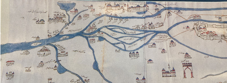
At more than four meters long, anyone taking the “Trumbull Map of the Euphrates and Tigris Rivers and the Gulf’ on a trip with them would need a large bag.
Produced between 1655 and 1669 CE in watercolors and ink, the map is currently on display in the permanent exhibition of Qatar National Library’s Heritage Library and is certainly one of the largest of its kind. Created out of eight pieces of paper that have been joined together, the map in total measures 4.29m x 0.43m. It sits in the “Setting Sail” section of the Heritage Library, alongside other charts and maps of the region, and historical navigation tools.
The map begins at Erzurum in eastern Anatolia in Turkey, at the headwaters of the Euphrates and Tigris and follows the rivers until their confluence at Shatt al-Arab which then runs in to the Arabian Gulf.
Along the way there are a variety of interesting features, including Noah’s Ark atop Mount Judi, an oil seep which is rendered in black ink, and the city of Makkah. The region where Qatar is situated is also on the map, but the country is not named, rather it is represented with a fort or castle, as is Kuwait.
Unlike modern maps, there are few geographical features, but cities, shrines, bridges and the banks of the two rivers are shown. The mountains that are depicted are rendered in green and yellow ink, while rivers are in blue. Due to the lack of geographical features, it is thought that the manuscript was possibly created for the use of merchants and pilgrims.
Indeed, it is named the Trumbull Map at Qatar National Library as it was taken from the region to the United Kingdom by Sir William Trumbull, who died in 1716, but who served as the English ambassador to the Ottoman Empire from 1687 - 1691 CE. As ambassador he would have had a keen interest in the trade routes of the time to help increase commerce with the British Empire.
Believed to be the oldest Ottoman map that includes the Arabian Gulf, the manuscript is thought to have been produced by the celebrated Ottoman traveler and explorer Evliya Chalabi. He spent 40 years journeying through the countries of the Ottoman Empire and wrote a famous travelogue documenting his voyages, the Seyahatname, sections of which can also be found in the main collection at Qatar National Library. The descriptions of places that Chalabi visited closely match descriptions of places on the map, suggesting – among other evidence – that he was responsible for both.
Qatar National Library’s Heritage Library is a treasure trove of artefacts with historical significance to the Middle East region and the preservation of such is vital to our understanding of where we have come from and where we are going. At the Heritage Library there are books, manuscripts, maps, globes, historical photographs, travelers’ tools and physicians’ instruments.
The Heritage Library is open Saturday to Thursday, 8:00 AM to 8:00 PM, and on Fridays from 4:00 - 8:00 PM.
Add new comment